Archive for January 2011

A Hole lot of hippies

[Marahau, New Zealand] That was a rough night. The wind had the van rocking so much it felt like it was going to tip over. Sand made it sound like we were being sandblasted and rain was being forced inside around the window rubbers by sheer air pressure. We hardly slept.

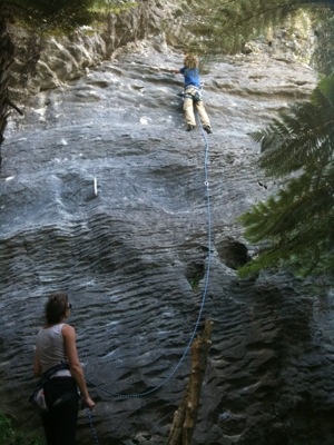
The plan was to take in the Wharariki beach arches, Cape Farewell (Northern tip of south island) and Farewell Spit (the longest natural sandbar in the world) even if the tide wasn’t right but the rain and wind had us waiting in the car park for an hour before we decided to give up and head back towards Collingwood. We were both more than a little annoyed. By the time we were approaching Takaka our moods, and the weather, were improving. We pulled in at the Paynes Ford car park to check out the crags. Some friendly Italian climbers let us have a look at their guide book. The area has over 200 bolted routes on great feeling limestone and the vast majority are moderate grades (just right to challenge my old bones). What a spot. After checking out a few of the crags we left wishing we had brought our gear.

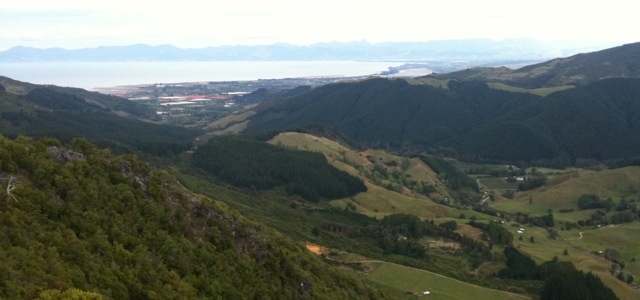
After climbing back up the insane pass we had tackled yesterday we took a narrow dirt road off towards the Abel Tasman National Park and an interesting sounding sinkhole called ‘the hole’. It was slow going on the little road. Lots of traffic in both directions and plenty of idiots hauling caravans up and down the rocky track. We found the explanation for the traffic. A week long music/hippie festival not unlike Splashy Fen complete with tee-pees, hula hoops and circular gatherings of guru guided pow-wows. At $80 per person to catch only the tail end of the festival these hippies must being doing quite well when they put some shoes on and get back to the real world 🙂 BTW: This part of NZ is hippie central with village streets lined with organic food stores and the endless bead and art shops.

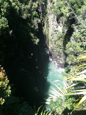
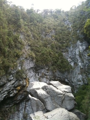
We cruised through the festival and eventually arrived at the Hole’s park area. The walk out took around 40 minutes on, as per usual, a perfect DoC trail. The Hole viewpoint offered views into the distance of dense forest. At the Hole itself we could not safely get a decent look at the drop-off, but it drops 178m! The largest such hole in the southern hemisphere (apparently) with some hectic caving opportunities a the bottom. Need to join a club and get back out here one day. Should be excellent. Walking back out we came across a couple we had passed on the dirt road. They had walked BAREFOOT from the festival. Got to respect that. One thing about hippies – they always make me smile.

Being the carpets that we are we got suckered into giving a lift to a young lady form Chile who was on her way out of the festival. Not that we have anything against hitchhikers, more that with no seats/seat belts in the back we could be fined. Anyway, we gave her a lift as far as we could and continued to Marahau on the coast. The campsite at Marahau is very popular being on the doorstep of the well loved coastal trail in the Abel Tasman but like every other place we have been to it was not full. I suspect it has been a terrible year for New Zealand tourism – amazing that the staff are still so happy and helpful.

[Pictures: Some climbers enjoying Paynes Ford and there is a beeeg hole just over that boulder]

– Posted from my iPhone via 3G

We keep running out of road!

[Wharariki Beach, New Zealand] We knew it was coming. A full and boring day behind the wheel. We started off by back tracking to Westport and that took one whole Skeptics Guide to the Universe episode (thanks ‘Link1’ open WiFi point at Karamea). From there the only thing of interest to us while heading around the monstrous Kahurangi National Park was the countries biggest bridge swing on the upper Buller gorge. A bit silly we thought, they don’t have free viewing platform so we just kept driving and the SGU kept playing. Eventually the epic forests and mountains turned to beautiful orchards and vineyards not unlike the Cape valleys, just more tidy.

Eventually we hit Tasman bay and turned left to once again start climbing up and over more crazy passes to Takaka. We stopped at a viewpoint and took a short walk along a forest trail but other than that we hardly left the car all day. From high on the pass stunning views had us peering into the distance over Tasman and Golden Bay. Not the best photo weather, but what can you do? We past a few interesting spots and barely slowed down since we will come back along this section tomorrow – caves, sinkholes, viewpoints, the Abel Tasman national park, and the countries largest and most popular sport climbing crags along Paynes Ford.

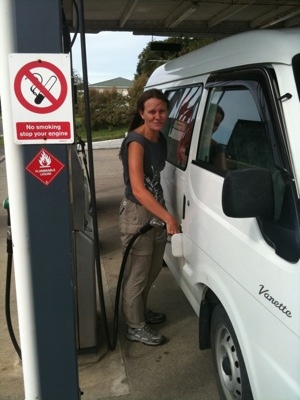
By the time we got to Collingwood we were almost out of petrol (again – averaging 10l/100km) and the wind was picking up (from strong to gale). The last 30odd km out to Wharariki beach were dodgy with our little van being blown around like a sail boat. Once more we found ourselves at the end of the road, this time at the northern most tip of south island. It was only around 430km in the day but due to the steep and windy roads we were in the car for 9 hours with possibly and hours rest. Tomorrow we will have to take it easy and stop occasionally to smell the flowers.

Wharariki beach (the end of the road again) has some amazing arches but they are only accessible at low tide (1:10am and 14:00) so it looks like we may miss them (this time). We were met at the campsite by the current manager. An excited young lady from Belgium who loves the place and is particularly impressed that everyone goes to bed at 10pm. We like that arrangement too 🙂 The campsite looks like Hobbiton would look if a tornado was passing through – gale force winds – tonight should be interesting.

[Pictures: A view of Tasman bay in the distance. Finally found a use for V and Hobbiton in a gale]

– Posted from my iPhone via 3G while pretty drunk

End of the road

[Karamea, New Zealand] Not in the metaphorical ‘end of the journey’ sense, but literally, today we drove north until there was no more road. The weather didn’t clear this morning but it did stop raining long enough for us to sort the van out and get back on the road with a damp smell just behind our heads. We blitzed through Westport (the only settlement of substance today) and carried on up the crazy coastal road that has been hacked into the sea cliffs.

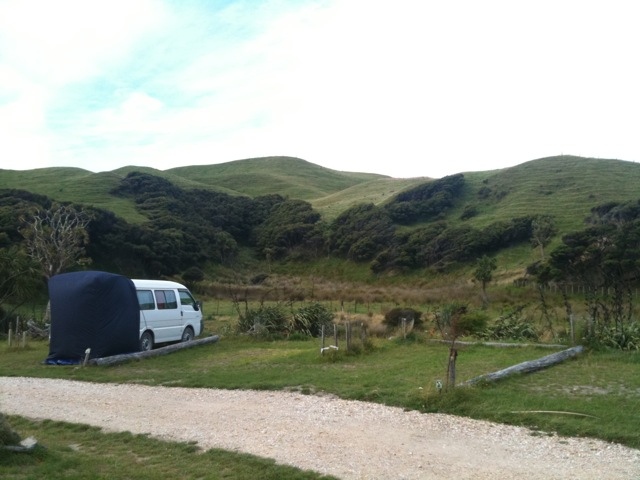
More small little villages with names like Fairdown, Granity and Hector had very little to look at besides the usual general stores, cafes and endless arts and crafts (although I did see more half-pipes). At Summerlea the road turns inland around an immense bluff. The road started to wiggle and climb. No idea what possessed them to build it just for a handful of villages. The views of tree covered mountains as far as we could see was again beautiful but it was a very long and slow ascent and descent.

Karamea (population 650, no cell signal) is the last village on the road. If you want to go further north you have to start hiking the Heaphy trail. We passed through following the tar road until we hit the gravel. We were heading for the Oparara arches but the road just kept going and going with nobody in sight. It was a little concerning. We came around a bend to find a bustling visitors centre car park complete with picnic tables, loos and information boards. You have to love this country!

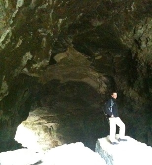
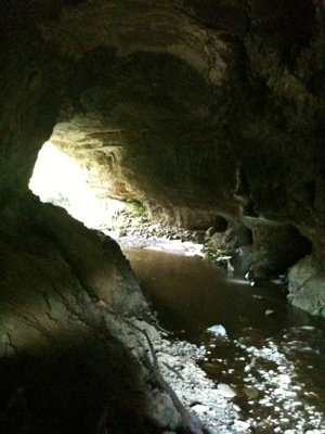
The Oparara arch is the largest limestone arch in the country (~200m long) and was only a short walk from the car park. It honestly was not too impressive. I guess we have been spoilt. The forest walk was atmospheric – trees heavy with moss with a tannin stained river bubbling below. We checked out the other (smaller) arch in the area and two caves complete with glowworms before heading back to Karamea. Sounds like the caves further up (Honeycomb Caves) are more interesting but access is restricted to guided tours.

Thankfully there was a petrol station in Karamea. All that dirt road meant we were almost out. We noticed a ‘Domain’ campsite sign and followed it along some municipal buildings. It lead to a perfectly manicured rugby field with a few ‘campervan sites’ dug into the bush along the touchline. The ‘facilities’ were too basic for us and our collection of damp gear so we opted for the fully serviced campsite on the way out of town. A really pleasant little spot protected from the wind and with the help of a little sunshine we were able to sort ourselves out. The best part was the discovery of a high speed and unprotected WiFi hotspot – the first time in NZ. No cell signal, but high speed WiFi? We internetted ourselves almost to death – it’s been over 3 weeks without WiFi! Hope we didn’t use all their bandwidth 🙂

[Pictures: Me and the Limestone arch at Oparara, not too impressive (me or the arch)]

– Posted from my iPhone via WiFi

Bambi sarmies and stone pancakes

[Punakaki, New Zealand] After yesterdays awesomeness today was bound to be far more subdued (besides the fact that we can barely move our arms and legs). We drove over to ‘the other local glacier’ (the Frans Josef) and stretched our legs walking up to the nearest view point. It was another spectacular view and the valley does look much deeper than the Fox glacier but cloud hid the top section. The terminal face looks very impressive. Massive.

Frans Josef township (ie village) was very quiet. Seems NZ tourism has take a big dip this year. We went in search of the indoor ice climbing wall marked in the LP guide but figured out that it is gone and the only building that could have been a climbing wall is now a freshly painted National Kiwi Centre. We grabbed a few essentials (milk, bread, biscuits, biltong!). The shop obviously caters for campers; at the checkout there was a box of single knives for sale for those nanas that have misplaced one from their rental vans. We grabbed one to replace the one I lost 🙂

We cruised through one horse towns and some slightly bigger ones occasionally stopping to snap a view but the weather was far from ideal. Harihari is a single street town with a monument and road side display commemorating the flight of Guy Menzies. The first person to fly from Australia to New Zealand. He crash landed in a marsh just outside of town. One thing I have noticed is that almost all of these tiny villages have a half-pipe. Must bring my board next time !

Pukekura, according to the 2007 LP guide has a permanent population of 2. We can believe it. It’s claim to fame is a road-side diner/museum/shop called ‘Bushmens Centre’. Morning tour buses and hard-core bikers frequent it and you won’t find a much more politically incorrect place in NZ. They used to serve up possum burgers but laws now prohibit it. Every surface in the place is covered with notices or objects that (depending on your sensibilities) are hilarious or insulting. It was an experience for sure and the ‘Bambi toasted sarmi’ wasn’t too bad either. For a bunch of gun toting rednecks they are militant environmentalists when in comes to 1080 poison. A chemical used by the DoC to reduce the possum and pest populations. I must read a bit more about it – the rhetoric in the cafe made us skeptical of their argument.

Hokitika is one of the larger towns on the coast but is still tiny – at least they have cell phone reception – our first for the day! The main tourist street is lined with Greenstone (jade) jewelery stores. V had a look around one but the stuff is just crazy expensive. We pushed on up the coastal road passing through Greymouth and noticed a turn-off for Taylorville – had to pop in for a photo of V’s own little town. A tiny village that time forgot with nothing going and nobody around. We had a quick look around and noticed a number of front lawns immaculately presented. Another odd little spot. Back on the road, the coastline was incredibly rugged and appeared treacherous and menacing in bad weather like today. In spite of the windy road and bad weather we arrived safely at Punakaki (still no cell phone).

The camp ground is very near to the beach and had more character than some but the rain was pouring and the wind howling. We had to wait a while for high tide – the recommended time to see the blowhole 5 minutes back up the road. The area is known for the blowhole and the ‘pancake rocks’ – odd geological formations that look like huge stacks of pancakes. The blowhole wasn’t impressive (we want a small one that produces a huge geyser) but the pancakes were cool even in the rain.

Cooking and just moving around in the wet and wind wasn’t fun. Seems our little tent for the rear of the van is not designed to handle heavy downpours. Tomorrow will be a very damp and muddy start. Hope it’s sunny!

[Pictures: Frans Josef glacier rushing towards us. Bushmens – odd spot. Hokatika town centre and V at home. Stone pancakes in the rain]

– Posted from my iPhone via WiFi

Whack and Dangle

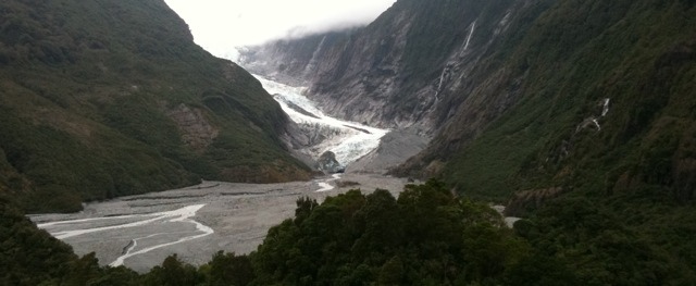
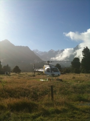
[Fox Glacier, New Zealand] When I got out of the van the moon was hanging high in the dark sky. It was early, but most importantly, the sky was clear. We walked over the street to Fox Glacier guides by 7:30 and got confirmation from Richard the dispatch guy that the good weather was expected to hold for the day – our flight out to the glacier was scheduled for 9:30. Excellent. Jonathan, our guide for the day, set about kitting us out with the required gear. Packs, gloves, caps, sunnies, boots, gaiters, crampons, helmets, jackets, harnesses and the coolest things of all – ice axes. The rigid boots are not the most comfortable things to walk around in (something like snowboard boots) and all the gear was top notch and well maintained. We got word that a flight slot had opened up (some people were late) so we stuffed our gear into the packs and headed out to the heli pad just down the road.

V had never been in a helicopter before and was just too excited. Our ride was a decently sized machine. A 6 seater, so V and I got to ride up front with the pilot. It never fails to amaze me how smooth these things are. The ride up the glacier was stunning but very short (We have lots of video from today – will upload when possible). We past the terminal face and continued over the lower sections where the guided day walks play before being deposited much higher up the 13km long glacier on a roughly flat and pristine piece of ice not far from the upper ice-fall. The ‘pad’ was busy with a large group of Heli-Hike clients being flown in for their 2 hours on the ice (We were on the ice at 9 and were not scheduled to leave until 16:30). After the last chopper left we were able to kit up and finally stand with confidence. Ice is slippery (no kidding) and crampons are amazing!

Taking in the surroundings we trudged up towards the upper ice fall leaving the Heli-Hike groups behind. The ice on the upper fall moves around 5m per day so no two days are alike. First up a short ‘bouldering’ session to get us used to the crampons and picks. Not too difficult but we immediately felt that our toes, calves and forearms were going to take strain today. With the basics under our belts in no time Jonathan led us on up through the gullies towards the ice falls. After scrambling and climbing our way through beautiful blue ice tunnels we stopped at a short (8m) off-vertical wall for our first toprope session. What a blast. After just having a whack at it we got some technique pointers. It’s amazing how little ice the picks and crampons need to provide a solid hold, but to learn to trust it is another issue. I also had a go at placing a couple of ice screws to simulate leading. My forearms where absolutely hammered after that attempt.

We carried on up the glacier as the terrain became steeper and much bigger – so much so that we were required to rope up on some sections. Another cave and hole got us out to a bigger and much steeper ice wall with a decent bulge in the middle and a slightly overhanging top section :gps:(GPS)::-43.50995::170.10144:gps: .”Jonathan has too much confidence in us” we thought. V had a good whack at the route while I found myself a loo with the ultimate view over Fox Glacier 🙂 V and I both had a hard time with the climb on our first attempt (forearms burning) but after some more coaching we nailed it. Nothing quite like the “Thunk!” of the axe going over the top lip.

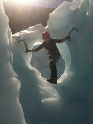
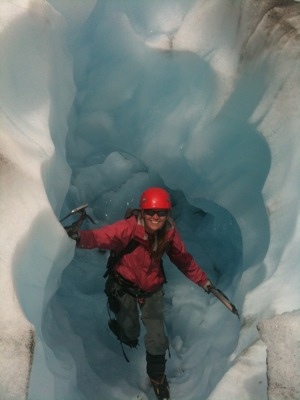
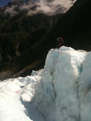
Besides being fit (obviously) and having a little extra gear we reckon the biggest thing in ice climbing is understanding ice in its various forms and the terrain. Jonathan fed us a lot of information, from geology to anchors, but we were having so much fun that most of it did not stick. I do remember him explaining that in hot weather like this the screw anchors for topropes would need to be checked every 20 minutes (ice has a habit of melting). A good reason not to hang around for long on the rope.

The cloud started working it’s way up the valley as we started back down. Jonathan spotted a beautiful ice cave and set up a line for us so that we could get through without falling into the gushing stream below. Once again we have been impressed with the professionalism of the guiding in New Zealand. Safety was always first. Jonathan spent some time ‘preparing’ the tunnel for us by knocking off dangerous looking overhangs and cutting steps in critical spots. V even got to have a go knocking a big chunk off – who needs global warming to destroy glaciers when you have a huge mountaineering axe 🙂

The penultimate feature that we found to play with was an insanely deep hole carved out by water. The water was still gushing in down one side. We could not tell how deep it was from above (probably more than 20m) so the plan was to lower us into the hole and let us climb out (or haul us out if things went wrong). As usual I was first up. I don’t usually have a problem with heights or tight spaces or water or ice (in scotch) but at around 7m down the waterfall was raging at arms reach and the ice walls had turned clear (I think that means that it is very hard ice). Any deeper and I would have gotten wet from the waterfall and I was nervous about climbing the hard steep ice so I had a look around (it was maybe another 10m to the bottom) and signaled up that I would start climbing out. It was an awesome climb out and it’s always good to have some form of motivation under you. V’s lil arms had given up on her for the day so we carried on down towards the heli-pad (a flat piece of ice). Jonathan found one more stunning blue-ice cave for us to play in before we had to return our cool sharp pointy gear (we are going to have to get some of our own I suspect).

There was one final little treat in store for us. The helicopter that was collecting us had a ‘scenic flight’ customer on board so we got to see a lot more of the glacier. The pilot went almost up to the cloud layer before circling back around. He came in close (very) to some huge boulders that were part of a recent rockfall and took his time getting out of the valley so it was a much longer flight than the ‘Taxi’ ride in. It was the perfect end to yet another perfect day. Ear to ear grins on both of us once again (I think they are more or less permanent now). We’ll suffer tomorrow, but it was well worth it (even at the price).

Thanks Jonathan (and Fox Glacier Guides). It was an incredible experience and we both loved it. Yet another thing to add to the list of cool sports we enjoy. We’ll be back, but probably with our own gear hehe.

[Pictures: Our snazzy ride, Mt Cook in the background. V playing around on some features. Jonathan setting a toprope and V looking back up to the icefall. We have loads more awesome pics and vids to come]

The heli ride onto the glacier

V having a whack at the Glacier

Us climbing through an Ice Tunnel

Sim in the Moulin

The Ride out

– Posted from my iPhone via WiFi

Hunkered Down

[Fox Glacier Village, New Zealand] We were truly optimistic this morning and presented ourselves at the Fox Glacier Guides offices at 7:30 even though there wasn’t a blue patch in the sky. Our friendly guide and the dispatch operator from yesterday informed us that the weather was not going to work today after pouring over various online weather resources. Lucky we have a backup booking for tomorrow. So it was straight back to bed for us.

We had plans to get up and possibly hike up to the glacier face or drive up to Franz-Josef to check out that slightly larger village but it started raining and hasn’t stopped. V’s been snoozing all day and I’ve been listening to podcasts. I reckon it’s for the better. We are both still in pain from the mountain biking and have not been able to sleep in for weeks.

Tomorrow the weather is expected to be calm and sunny – let’s see how good the forecasting is in NZ. The only problem I see is if the helicopter drops us high on the glacier in the morning and then is not able to collect us in the afternoon due to weather. It’s too far and dangerous to hike out so it could be quite an adventure.

[Pictures: Hi Mom. The view out the back window]

– Posted from my iPhone via WiFi

Wild West?

[Fox Glacier Village, New Zealand] Longest amount of driving thus far-360km from Queenstown to Fox Glacier. We opted for pancakes at McDonald’s for breakfast instead of weatbix, mainly because we knew there was free WiFi there. Except the unlocked WiFi from the other day had now been locked and limited to half an hour access. Pancakes chomped we headed off for some supplies and onwards to Fox, stopping first at Arrowtown and then at a bungy spot further down the road. Arrowtown looked quite charming if that’s the right word for it. An old gold mining town that has been nicely restored. We cruised through town but did not really stop.


Our next point of interest was the LOTR filming location for the pillars of the kings scene. We pulled off the road at a likely spot disturbing a family of Californian quail ( I looked them up in the bird book the Ewegs lent us) but could not get close enough to the edge off the gorge. So we carried on down the road until we saw the AJ Hackett bungy centre located on an old bridge over the Kawarau river. Another slick operation. Nice modern building built into the cliff side with a viewing platform so you can watch people hurl themselves off the bridge. We watched a few people do this very calmly without any screaming before we got bored and moved on.

We took the Crown range road to Wanaka. It was quite a climb up over the pass in our little van. We could smell the clutch struggling a bit. The plaque at the top said it was the highest paved road in NZ.

Wanaka looked like a smaller more chilled version of Queenstown. We might have stayed to explore it but we had a glacier to get to. We found out later that some of the countries best rock climbing is in Wanaka. Will have to check it out at a later date.

Sim and I swapped over at Wanaka with me behind the wheel for the 140 odd km through the southern alps to Haast on the west coast. It was a beautiful drive first along the edge of lake Hawea then along lake Wanaka before heading through the tree filled Mount Aspiring national park. It seemed to be a popular route with cyclists and hitchhikers alike.

The national park was really a treat to drive in. The road followed the Makarora River upstream then at some point we crossed a watershed and the water was flowing the opposite way and we following the Haast River. Both rivers had the beautiful blue green colour we are so fond of and we stopped to admire numerous waterfalls along the way. At one point we crossed over a bridge at a point on the river named the ‘Gates of Haast’. It was a picturesque steep cliffed gorge with the blue green water thundering through some rapids. We will have to look up the history on that one some time.


Arriving in Haast we were finally in Westland, the rugged, sparsely populated western coast of South Island. Haast had nothing to tempt us with except a fuel station which must do very well as it’s the only one in a 120km radius. We filled up and drove on stopping only at Knights Point lookout to check out the stunning view and sample the sandflies.

When we got to Fox Glacier Township (not the same thing as an SA township), the guide shop was still open so we popped in to find out about the weather prospects for the next 2 days. Sim had phoned Fox Glacier Guides up a couple of days ago and booked us on a heli ice climbing trip. The idea is we get flown up the glacier in a helicopter which will then land on the glacier dropping us off for a day of ice climbing before picking us up again later and flying us back. How cool is that? The critical thing though is the weather. If the weather is bad, the chopper can’t fly. Since it’s a rather expensive treat for us (£600 ouch) we want to make sure the weather is optimal so we have set aside a couple of days that we are prepared to hang around. So the good people at Fox Glacier Guiding have made some back up bookings for us to make sure we get what we want. The staff have been brilliant and it makes a big difference when you mention you have been climbing for the last 15 odd years as these guys aren’t just doing a job, they are climbers getting paid to do what love. Anyway, we had a chat with one of the guides and looked at the weather for the next 2 days. Tomorrow is not looking so great but who knows with the weather. We will have to check in tomorrow morning to get a better idea.

P. S We have discovered the twin joys of the West coast. When the sun goes down and the blood sucking sandflies go to sleep, the blood sucking mosquitoes come out. They are pretty slow moving though and we still spent quite some time squashing them against the inside of the van roof before we went to bed.

[Pictures: River gorges, bungee bridge, more gorges with white water, pretty waterfalls and sea views]

Last little snippet of a Loony Bungy jumper

– Posted from my iPhone via WiFi

Gravity… Why fight it?

[Queenstown, New Zealand] WARNING. Geat day = long post.
Yet another perfect weather day, it even felt hot and the cold breeze must be busy somewhere else. We were up very early to be in time for the canyoning. Typical, we were a half hour early, but killed the time on McDonald’s free WiFi connection that for some reason was not asking for the usual login (some IT guy is gonna be in trouble). We had a group of 10 people with 3 guides. I won the age race again by at least 10 years. It was a short ride out to the canyon and in no time we had been kitted out in 7mm full length wet-suits, booties, life vests, helmets and harnesses.

Before walking up river we had a chance to sample the water, it was around 6 degrees Celsius. Brrrr. Thankfully for the first few canyon crossings we were high above the river on zip lines. Once again the guides were excellent. Everything was checked and double checked on each person. A well oiled and professional operation with a lot of simple (some hardly noticeable) steps to ensure safety. After the zip lines (which were short and slow compared to what we are used to) we were lowered into the canyon and got to experience a small slide. Hitting the water was so cold it knocked the wind right out of us. This was followed up with a decent (7m) waterfall jump into deep water. As usual I somehow found myself at the front of the queue. V had managed to wiggle her way to the back and had initially opted to be lowered down but to her credit she didn’t chicken out – she was rewarded with a nose full of icy water 🙂

Jumping, wading, sliding and scrambling got us back out of the canyon to another zip line. This time the object was to zip to the middle of the line and then abseil down to the water. V and I were the last to go and we were just chatting about how not to mess up the simple procedure involved. V was a little concerned but had no problem in the end (just like the other 8 people before her). Then I stepped to the plate and forgot to release the safety before starting the abseil. Doh. What a gonk! In my defense I have never had an additional safety to remove before abseiling. All I needed was 15 seconds to tie an 8 and step up to release the safety but the guide was hauling me back in before I could turn around. V is never going to let me forget that one. Scrambling around the rocks I put my hand down to balance myself and felt a pop in my shoulder accompanied with excruciating pain and loss of motion in my arm. It is impossible to keep you muscles warm in this cold water is my excuse, but really I think I’m just getting old. I managed another bigger jump (maybe 8m) but V did opted out (paaak pak pak pak), and were on our way sliding and wading towards our exit point but not before another icy dunking (I suspect the guides favorite part). By the time we got out of the canyon a few of us were starting to shiver and turn blue but it didn’t take long to warm up in the sun.

Back in town we rushed back to camp (ibuprofen rocks) swallowed as much lunch as possible and then walked up to the gondola to discover that ‘half-day’ pass meant from 3pm until 8pm. With an hour to kill we chilled out back at the van and then tried again with more success. The views going up the gondola and from the skyline complex at the top are stunning. This place has a lot to offer.

Vertigo bikes is yet another fantastically run organization. We decided to rent some full suspension downhill bikes (full face helmets included, body armor as an optional extra) and they were in perfect condition. They even switched the hydraulic disc brake levers around for V (she’s not normal). Not familiar with the bikes or trails we took the easiest route down (an 8km green trail). It was awesome and to give an idea it was comparable to the black (hardest) runs in Wales with options which look positively life threatening (huge jumps, elevated Ewok village trails etc). Then the best part. The guys at the gondola hooked our bikes on and in no time we were back at the start and ready to go again with ear to ear grins. We love gravity assisted sports.

Gaining confidence we hit the same route, but this time a lot faster making full use of the burns and small jumps. The bikes instill a lot of confidence – obstacles that would throw me off a hard-tail just get smoothed out with the dual shocks. It’s an incredible feeling and the best value for money thing to do here. Also the most adrenalin inducing. A bungy jump you ‘know’ is safe, but careening through a forest over jumps and obstacles is infinitely more dangerous – and the outcome is far from certain. Just to prove the point we opted for a blue run on our next descent. It was STEEP and accompanied with shrieks of exhilaration/fear from both of us. I accidentally ended up on a black run headed straight down an insane trail. It wasn’t long before I was thrown over the bars and was being chased by my bike as I rolled head first down the trail. Confidence crushed and in some pain I found my way to a road, met up with V and continued down the blue run at a more conservative pace.

Back on the green run and by half way, having forgotten the earlier spill, I was gravitating towards the more technical options. A small gap jump landed me on a rock which punctured my tire. V continued on alone as I pushed back to the top along an access road. One thing about downhill bikes, they are HEAVY. I got to the top completely spent at the same time as V. It took 30 minutes of slog up the road. Chatting to the locals it seems that the gondola has not been available to bikes for too long and this is the first year that riders have been able to buy a season pass. I can’t imagine having to ride (or push) all the way up, but it would have been worth it – the trails are genius.

We did a few more runs (6.5 for me in total and 5 for V – the locals do 8 or 9) but the last ones were hard. Never again will we diss downhill mountain bikers as lazy – this stuff takes a lot of fitness. With time running out I set off on one last cannonball run. Too fast, too tired, too unfit and not enough skill had me bouncing down the trail again. How often can you have a huge grin on your dial with blood dripping from a bashed knee and covered in grazes and aching bruises. We love it!

It was a long hard day at play. Luckily we are spending tomorrow driving as I doubt either of us will be able to walk. Thank you Queenstown. We will be back (just need to rob a bank first).

[Pictures: Queenstown from the Skyline complex – Stunnning. All the other pics are on the camera so you’ll have to wait]

– Posted from my iPhone via WiFi

Just short of Paradise

[Queenstown, New Zealand] We can only spend two full days here in Queenstown and have to balance that with our budget, which is running tight, and with the plethora of ridiculously fun activities around town. After pouring over the brochures last night we have decided to do some Jet Boating, Canyoning and Downhill Mountain Biking. We figured 8.5 seconds of bungy is just not worth NZ$280 each!

First order of business was to walk into town and make some arrangements. Queenstown looks and feels like a purpose built resort town (something like Whistler). As we headed down to the centre under perfect clear skies we could hear screams of terror/joy from the half dozen or so tandem para-gliders up the mountain. We booked the canyoning for tomorrow morning and the bikes for the afternoon. What luck! The gondola opens for bikes tomorrow. That should be a blast.

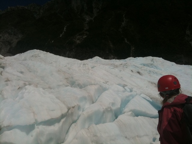
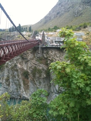
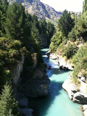
We debated the jet boat options and settled on the one which looked the most life threatening (albeit more expensive for less boat time). The Shotover Jet boat operation is one slick machine. We arrived at their main office (they have many), paid, and within 10 minutes were on their bus out to the canyon with promo video and seat-pocket instructions in every language you could think of. 20 minutes later we were at the riverside kitted out with life vest and spray jacket staring down one very steep and narrow but beautiful canyon.

Now a bit of advertising for Shotover Jet. The boats are brilliant. Capable of navigating in 10cm of water at speeds up to 85km/h through some very tight canyons. Two 3.8l V6 Engines are hooked up to simple water jets developed in New Zealand allowing for the shallow operation and 360 degree spins. Apparently the company was one of the first ‘adventure tourism’ operations in Queenstown and has ‘thrilled over 2.5 million people since 1970’. That’s not hard to believe.

The ride was exhilarating to say the least. V and I scored the front seats and V, being on the outer side was screaming like a little girl as our pilot came within inches of the canyon walls and mid-river boulders at crazy speeds. The 360 spins were brilliant – resulting strained necks and the entire boat being soaked. Without a rudder or directional prop and a flat bottom you are just sliding around on the water in whatever direction the jets are pushing. Fantastic fun that was over too soon but well worth it. Within a minute of getting off the boat the operation had a video and photos of our run ready to purchase. Like I said, slick. We hung around a bit and took some video and pics of other groups hurtling through the canyon before catching the bus back to town.

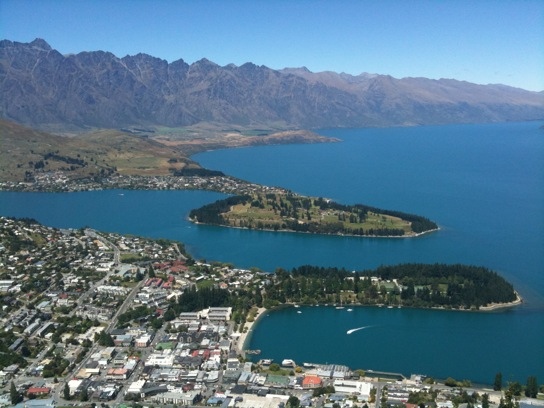
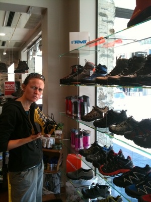
With a town full of outdoor gear and toy shops it was impossible to stop V from doing a little window shopping. We spent a good hour checking it all out and getting a little frustrated – gear here seems to be more expensive than in the UK – that just doesn’t seem right. Guess most of it has a long way to go to get here. We ‘splurged’ on a delicious ice cream (V tried the local fave ‘Hokey Pokey’) on our way back to the campsite and passed a Queenstown icon, Fergburger. A burger joint that always has a queue out the door, it must be really good or cheap, but nothing is cheap here so we suspect the former.

We spent the afternoon cruising out along the lake towards Glenorchy. The drive along the windy lakeside and the views were magnificent – we stopped again at just about every viewpoint to take a pic. Glenorchy is a tiny little village with not much to look at so we continued out towards Paradise. The road soon turned to gravel and that was that, we were done for the day (honestly – who would put paradise at the end of a gravel road?)

Tomorrow should be a lot of fun, but you can be sure we’ll be completely knackered by the end of it.

[Pictures: A ‘wide’ part of Shotover Canyon – Spot the boat? V is such a chick sometimes, shoe shopping again! A view of lake Wakatipu]

Shotover Jet Boating.. Yeee Haaa

– Posted from my iPhone via 3G

Now that’s a FIORD!

[Queenstown, New Zealand] Pancakes for breakfast! Lovely. Being bitten by sandflies and having to fish them out of our tea and pancakes – not so lovely. We had to resort to strolling around the van while eating just to keep away from the nasty little buggers. It seems they are unable to keep up when you walk. It also appears they are indiscriminate blood suckers as they don’t mind munching on me even when the tastier option of Simon is right next to me. I’m also choosing to blame the loss of my flip flops on the little buggers. Found out later that I had left them behind in our hurry to escape the camp site.

Sim was correct in postponing the Milford Sound cruise till today. Today’s weather was far superior – not raining and with just a few patches of cloud in the bright blue sky.

We checked in and hung around our boat the Milford Mariner. Real Journeys has some nice rides. We cruised on out of the little cove along with 100 other passengers (they counted us).

There is a reason Milford Sound is more famous than Doubtful Sound. It is just more spectacular. It may be smaller and there may be more boats on the water, but the narrowness of Milford make the sheer cliffs on either side just more impressive. We spent the entire 2.5 hour cruise outside on the front deck of the boat just going ‘Oh wow’.

We got some good shots of Mitre Peak (it’s on every postcard and Milford brochure) and we saw the impressive Stirling Falls (150m) which was dwarfed by the 1300m high mountains on either side of it. The captain even poked the bow of the Mariner into the falls, spraying everyone on deck and joking that the falls is also known as the Milford boat wash (har har). It did illustrate very clearly how vertical the cliffs are and that they extend a good distance below the surface of the water (200m+) We got up close to the rock a couple times to check out fault lines, interesting colorations and of course some seals which were lounging around as usual. We also sailed or rather motored into the Tasman sea. It was calm today but apparently it gets pretty hectic at times with 20m+ swells.

We were thoroughly impressed with Milford Sound. Sometimes when you hear about these things it’s all just tour company hype but Milford deserves being raved about by everyone. It was stunning and well worth the drive out to get there.

On the drive out of Milford, we stopped at the other side of the Homer tunnel for a late lunch. We can’t express the absolute joy we have over a simple thing like stopping by the side of the road and being able to make ourselves a peanut butter sandwich. This is the way to travel!

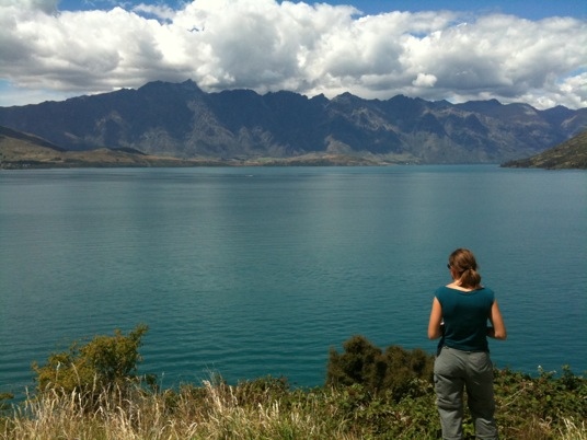
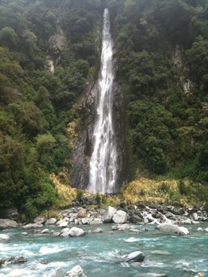
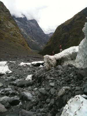
After lunch we stretched our legs by hiking up to the waterfall and the patch of ice below it. We had a jol rock hopping to get there then messing around in the ice by the river. It was a fun diversion before the long drive to Queenstown.

We reached Queenstown and our most expensive campsite yet (40 dollars for an unpowered parking bay and showers are 2 dollars for 8 minutes). It does have a resident flock of ducks that waddle around though. We had a quick look around town (lots of outdoor shops and adventure activity operators) and picked up some brochures from the wall of pamphlets at the camp reception. Looks like the next 2 days are gonna be expensive but a helluva lot of fun. If it makes adrenalin then you can find it here!

[Pictures: What a view to wake up to! I thought Mitre peak was a mountain not a volcano? 150m waterfall off in the distance and Mitre Peak again. Playing on the ice near the waterfall.]

– Posted from my iPhone via Expensive 3G

Squashums

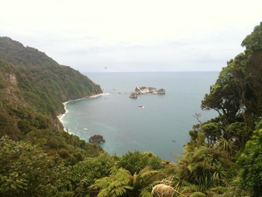
[Milford Sound, New Zealand] After stopping in town (Te Anau) to pop into an outdoor equipment shop (V just can’t resist), we hit the road bound for Milford Sound. The trip is, according to a few sources, the most beautiful road trip in the world. It’s only 120km, but we agree. Stunning.

The first section follows the shore of lake Te Anau and we stopped a couple of times to take pics in the perfect weather. After 30km the route kinks away from the lake and starts following the Eglinton river. The traffic was getting heavier the further we drove. Chains of tour buses and camper-vans of varying sizes kept the road busy, this being the only way to and from Milford. At each lookout or viewpoint there were at least a couple of cars and buses but they all cleared off quickly so it wasn’t a problem.

Before entering the Fiordland National Park (free) we were driving along a huge valley floored with rocky grasslands and walled by spectacular hills. Entering the park we drove into a solid wall of trees as far as you can see in either direction. We passed a number of DoC campsites (with ‘self check-in’ drop boxes and pulled in at Mirror Lakes. A wooden walkway led us (and loads of other tourists) down along a few pristine lakes in front of a backdrop of dramatic mountains. Pity the wind had started up and the clouds were moving in because you can see these pools would have provided amazing ‘reflection’ shots. The sign across the lake had ‘Mirror Lakes’ printed as a mirror image so you could read it in the water – what a sweet touch.

I think we stopped off to take photos at just about every viewpoint from Mirror lakes to the Homer tunnel, taking in the vast valleys, snow covered peaks and crystal clear streams. At a couple of stops we encountered the odd Kea, usually being fed by tourists who were blatantly ignoring the ‘Don’t Feed the Kea’ signs. The Kea is the only alpine parrot in the world (nesting in snow). They look cool (like fat, green parrots with big beaks) and like humans (and the food) but they can be a problem. They have been known to pluck and chew wiper blades and the rubber from around windscreens. With that beak I can believe it. Talking of wildlife, I’m sure we mentioned the possum in an earlier post. These guys became a pest here after being introduced ages ago. You would think that the numbers are under control from the number of squashums we passed today but apparently not.

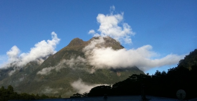
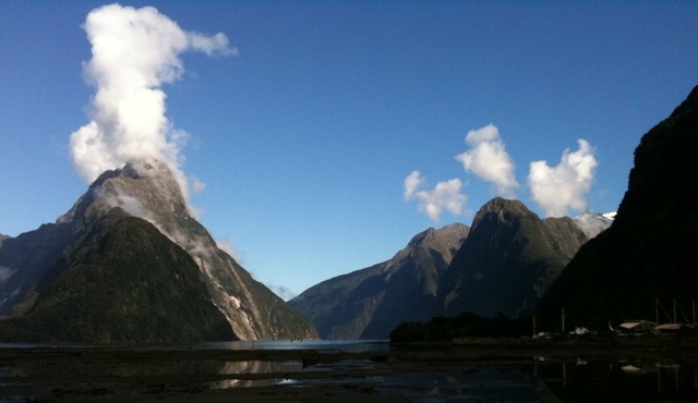
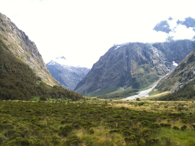
We also passed a lot of trail-heads mostly full of cars (it’s the weekend and the Kiwis are restless) There are a lot of great multi-day hikes that you can do from this area. We have got to do a few someday, the place is too awesome not to. It is also simplified, for example, there is a company called TrackNet that will fetch or collect you at trail heads. And no need for tents. As long as you book there are convenient huts on the trails. We love this place.

Homer tunnel is ‘one way’ during the day so we had a short (15 min) wait in front of a huge rock wall. To our right in the distance was a towering waterfall and large patch of snow/ice. We’ll have to take a walk up there on our way back to check it out. The tunnel is around 2km long and very steep (down), hope the van can make it back up. More breathtaking scenery as we started dropping down towards Milford. We stopped off at a short walk called ‘The Chasm’, because it is one. Raging water rushing in a beautifully formed gully beneath the walkway. Brilliant.

By the time we got to Milford and the huge ticketing offices (looks more like a small airport terminal) the weather was changing but we bought a ticket hoping it would pass by. With a couple hours to kill we had a very late lunch and then the rain started. The sound was obscured by heavy cloud. It was not looking good. Luckily we were able to change our ticket for the morning – may as well take the chance, how much worse can it get right?

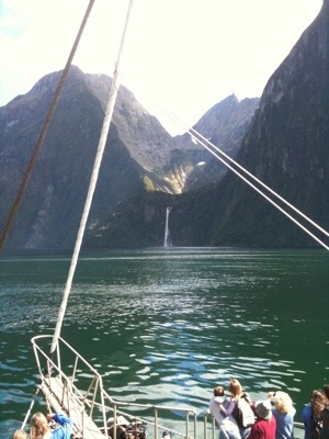
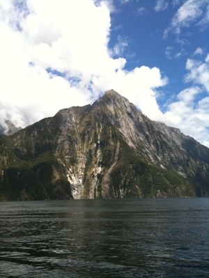
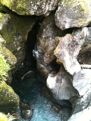
We managed to get a site at the only campsite in Milford (the DoC sites being the far side of the tunnel) which was very expensive (NZ$44, £22) with all the expected facilities. A small parking lot style site but this time teeming with sandflies. Once the rain stopped and the clouds started clearing the view and river alongside made it all worth while. What a stunning spot to camp. The weather-man says tomorrow will be clear and calm. Let’s see!

[Pictures: Cute little window rubber eating Kea. We have hundreds of shots like this (hopefully better) from today. Waiting at Homer tunnel. Peering into the Chasm]

– Posted from my iPhone via expensive 3G

Not at all Doubtful

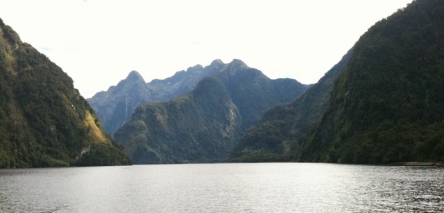
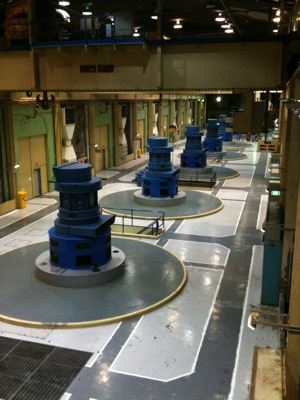
[Te Anau, New Zealand] Our first Kiwi ‘tour’ today out to the Manapouri lake hydro-power station and over Wilmot pass to Doubtful sound. The weather in the morning looked promising but it changes so quickly and by the time our boat was ready to leave at 11:30 it was overcast. ‘Real Journeys’ seems to be the major player in the tour business here. A big and very spiffy cat, capable of carrying at least 100, arrived to take us and the 40 odd other tourists across lake Manapouri to West Arm and the power station. The hour long ride passed easily as the captain pointed out islands, gullies and other features. The walls of the lake were very steep and occasionally rise over a thousand meters to the higher summits. The sheer rock is covered in trees that have grown on top of the lichen, intertwined with other trees and hanging on to the occasional crack. Here they have tree-falls, not rock falls. When a tree comes down it takes all the connected tress with it and the snowball effect rips a gaping rock strip down the side of the mountain. It takes 75 to 100 years for the tree slope to recover.

Manapouri power station is awesome! From the visitors centre we boarded a bus and after notifying the control centre at Twizel (more that 200km away) descended over 200m through a spiraling tunnel to the machine floor of the station. It was an immense engineering project. 7 huge turbines generate some ridiculous amount of power (14% of the country’s requirement at one point). Environmentalists in the 60’s halted the raising of the lake level so the station has only been running at full power for the past few years (smart engineers built an extra tunnel). I’m always in awe of this kind of thing.

From the power station our driver and guide took us over Wilmot pass (another impressive feat of engineering). Rex (the driver) filled us in on the area, it’s history and the flora and fauna in his flat monotone voice. Even the jokes were rendered in the same tone. I’m not sure if he was bored of doing the same talk day after day or if that is just his way. Either way he was entertaining.

From the top of the pass we got our first sight of Doubtful Sound (actually a Fiord). Impressively steep rock walls stretched into the distance. An even larger and fancier cat was waiting at the docks to take us out on the sound. Not long after leaving port we were joined by a large pod of bottle nosed dolphins – the juveniles where having a ball jumping out of the water – so cool to see. The fiord tour itself was excellent. Steep tree covered walls, vast mountains, gushing waterfalls. All kinds of information from our guide as we cruised along and definitely more impressive than the fjords of Norway (Norway’s fjords are much longer but just did not feel as impressive).

The name ‘Doubtful Sound’ was from Captain Cook who marked it on a map as a warning to other sailors. He was doubtful that he would get the winds needed to get his ship out if he entered the sound, so he didn’t go in. We eventually popped out into the open sea at the mouth of the fiord to visit a colony of NZ fur seals sunning themselves on a collection of small islands before turning around and heading back up the fiord. On the way back we had more dolphins. This time even closer and playing in our wake. Great to watch.

After the cruise it was just a matter of the bus ride back over the pass and another boat ride across the lake. We got back to the van around 8pm and then had to drive up to the next town (Te Anau) to camp for the night. It was a long day even though we were passengers, but it was worth it (even for the price).

[Pictures: Big stuff in the power station 200m under ground. The view of Doubtfl sound from the pass. Heading home – just another stunning view of the fiord]

– Posted from my iPhone via 3G

Welcome to Fiordland. Better get your beanie out.

[Manapouri, New Zealand] We left Tuatapere at our usual departure time this morning. Most campsites have a 10am check out so we aim for that but not before frying up some bacon and cheese baps for breakfast. Today was going to be a very light day and thankfully the weather was looking a little more cheerful than yesterday. With our gas bottle refilled we hit the road, the destination for the day being only 80 odd km away. We stopped off at another old suspension bridge near Clifden. This time we could not drive over it (or even walk) – huge concrete blocks and warnings signs indicated it was structurally unsound.

Not far from the bridge are some limestone caves that looked like a lot of fun. They stretch for a few hundred meters and require scrambling, climbing and crawling to access the depths of the unregulated caverns. Unfortunately after 30m of stumbling we realized that our little headlamps with their 8 month old batteries were no match for the inky blackness even after our eyes had adjusted. It would not have been safe to continue with light that barely rivaled our cell phones so we opted out. Such a pity. I love caving. We’ll have to come back someday (with ropes for the ‘expert’ section too).

Disappointed we cruised on to Manapouri and stopped in at the ‘i’ site to book a tour out on Doubtful Sound tomorrow. NZ$265 (R1400) per person! Ouch. That is worse than Norway, oh well, we have come all this way to see the Fiords (spelt the Kiwi way) so why not. Lake Manapouri is the second deepest lake in the country and from our lunch spot on the beach we had stunning views of the fiordland across the water. The overcast conditions yielded occasionally to blue sky and sun beams illuminating the distant mountains – it was a great spot for a sarmie.

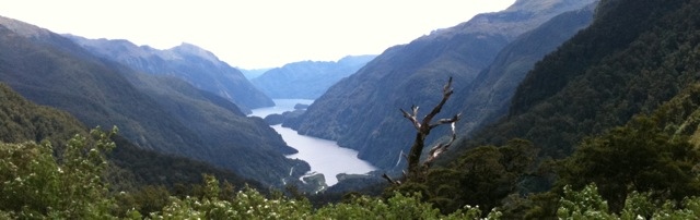
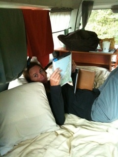
We found a small campsite (maybe 10 sites) close to the lakeshore as the rains started once again. Fiordland gets between 5 and 7 METERS of rain each year !! The temperature dropped dramatically and we settled in for a lazy afternoon. V is catching up on some reading while I finally get the blog up to date. It’s been good to have at least a half a day off, we’re both feeling a little road weary. Tomorrow someone else is doing the driving for us. Should be good (at that price it better be).

[Pictures: The suspension bridge at Clifden. V catching up on some reading]

– Posted from my iPhone via 3G

Star Trek Loo

[Tuatapere, New Zealand] A less hectic day today but we did do more driving than average. Our total distance is now just short of 2000km and the van is doing fine. We left Curio bay after a luke warm shower and under perfect blue skies (it was even hot). We headed for Slope Point :gps:(GPS)::-46.67388::169.00143:gps:, the southern most point on south island and by default the southern most point on our trip. A short stroll across sheep filled farmland got us to the markers and the obligatory photo. The wind was starting to pick up and by the look of the hunched over trees around it is not a wind to do battle with.

Invercargill was our next ‘city’. It’s the 3rd largest city on South Island (Southernmost city in the world) but the wide streets devoid of traffic made it feel like a dorp as we drove past the outskirts on our way to Bluff at the end of the peninsula. We lunched at the Bluff view point with sand-flies and the smell of a burnt clutch (the road up was almost too steep for the van). After taking in the 360 degree vista we headed down to Stirling point and the very end of the road. A sign post indicated 18 958km to London (it’s only taken us 8.5 months!). We were also lucky enough to spot a small pod of dolphins playing just off the point. The public loo deserves special mention with it’s automatic door complete with Star Trek sound effect, 10 minute usage countdown and bowel relaxing music. I just want to know what it does to you when you have used up your 10 minutes ?

We stopped briefly in Invercargill on our way back for fuel and supplies. We like the ‘New World’ food stores – you get a discount coupon for petrol from them which comes in handy. We took a walk/run along the main street just as the rain started to bucket down, snapped a few photos and bailed back into the van. Seems we are getting fussy. Campsites at Riverton (the oldest town on the South Island) and Colac Bay did not reach our ‘standards’ so we just kept driving.

On the way to Tuatapere is a ‘Gemstone Beach’ where you’re encouraged to collect a few stones. We were the only ones there. Not surprising the rain was pouring down. I think we lasted around 5 minutes. Tuatapere is another tiny town but declares itself ‘Sausage’ Capitol of the world… Hmm… Wonder what the Germans have to say about that? Anyway we found a campsite (after checking 2 that were wither closed or not acceptable) and took shelter from the rain in the common kitchen. ‘Shooters Backpackers’ campsite was empty but the rooms were full of much older folk and a young German couple on touring bikes. Riding in the rain today could not have been much fun! V made good use of the kitchen baking us up a pizza as I relaxed at the dining table. These camp facilities never cease to amaze – you really don’t need your own stove, pots, pans, cutlery or crockery when you go ‘camping’ in New Zealand.

[Pictures: A view from Bluff (yip it was overcast). It’s another sign ! and Invercargill town centre in the rain]

Some Not very extreme sheep herding

– Posted from my iPhone via 3G

Scared trees and a hole lot more

[Curio Bay, New Zealand] Wow what a day! We set off for Nugget Point around 10:30 after enlisting the help of some Poms and Germans from the camp next door to give us a push (the van got a tiny bit stuck in the mud getting out of our secluded site).

Nugget point was lovely. A tiny little lighthouse perched on some cliffs at the end of a bluff with seals cavorting in the rock pools far below. The DoC had also put up some thoughtful information plaques which had been written in the form of poems. Very different.

Then we were off to Cannibal bay. A nice bay with soft sand and a solitary sea lion basking in the sun that had finally come out. He was encircled by half a dozen tourists all taking photos. We did not stay for long, backtracking up the dirt road, back to the main road, heading for Owaka for fuel and milk.

In Owaka we found Teapot Land. Someone had collected a huge number of teapots and arranged them all in their garden facing the main road. It was slightly bizarre, but we were happy to donate a dollar and take a picture of this unexpected quirkiness.

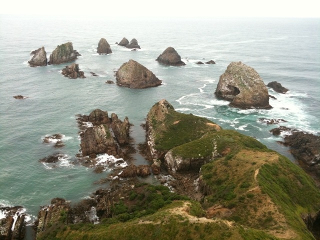
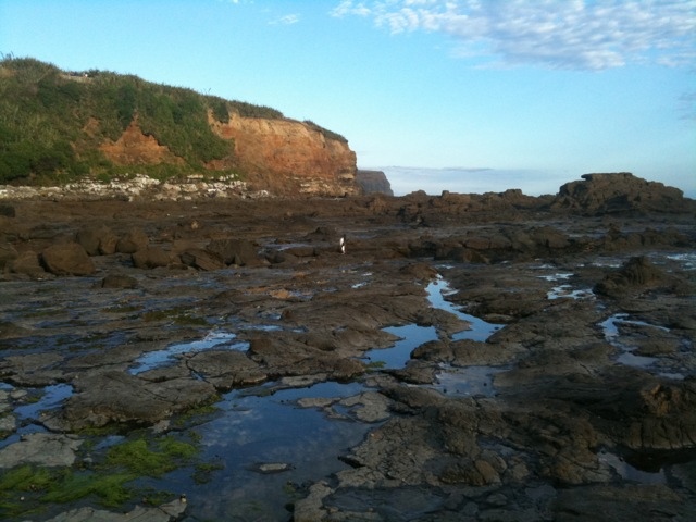
After Owaka we hit Jacks Bay and after a quick bite to eat (chip sandwiches) in the car park looking out at the beach, we took the 20minute hike up to the blow-hole. Jacks blow-hole is 200m inland, 55m deep, 144m long, 68m wide and other dimensions as well. It wasn’t really much to look at, but Simon really enjoyed himself.

By now, the usually chilly weather had turned positively hot and when we got back to the beach, the water actually looked enticing. There were a couple of kids body boarding in it so how bad could it be? It was freezing! Sim got in as far as his knees, I only stuck a toe in. Hardcore Kiwis, they seem to be immune.

Back onto the scenic highway, we called into Purakaunui Falls which was nice but not too impressive, and passed loads more scenic coves and bays as well as the obligatory sheep of which there are gazillions of. In Papatowai we visited the Lost Gypsy Gallery.

What an absolutely brilliant little spot. An old bus and a back yard full of creative mechanical/electrical ‘artwork’. It was the best ten dollars we have spent thus far. Fabulous. My fave was the simple hand wound whale out front. Sims was the bizarre keyboard hooked up to all manner of odd things from electric toothbrushes to doorbells.

We debated calling in at Cathedral caves, but since you can only walk thought he cave at low tide (2 hours later) I decided to move on.

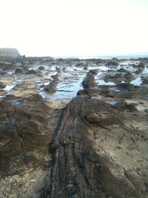
We reached our campsite at Curio bay at around 5. An amazing spot. Its high up on a bluff overlooking the sea. The individual camp spots are hacked out of the vegetation and we have found ourselves a nice little one with a view of the sea with waves that crash onto a rock outcrop below. What a view. It’s on a bit of a slope, but Sim is determined to figure out a way to get the van level.

It has been a long day, but it was still not over. After dinner we popped down the road to the petrified forest which also happens to be the spot where a small colony of yellow eyed penguins nest. We watched a couple of them come ashore and spend ages pruning themselves before waddling and hopping across the rocks to their hillside nests to feed their kids.

We have spent a good part of the day on dirt roads (we have been on lots). They are in good condition, but everything in the van including us is feeling a tad dusty. Cell signal is also pretty patchy. We are starting to recognize some of the other tourists along the way. It’s hard to get off the tourist trail when there are not that many roads to choose from.

[Sim: BTW. I got the van perfectly level with a ditch made by wheel-spinnig and a rock under another wheel]

[Pictures: The stunning view from Nugget point lighthouse. Peering into Jack’s Blowhole. Techno-Gypsy bits and bobs. Scared trees. Spot the penguin]

Couple clips from the Gypsy Gallery

– Posted from my iPhone via 3G